|
Abercromby Land Map 1737:
 MARLBORO COUNTY SC MARLBORO COUNTY SC
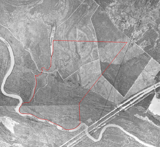
This aerial photo of the southern tip of Marlboro County, South Carolina
near the Dillon County line [shown], highway I-95 [shown] and the Great Pee
Dee River [shown] has superimposed on it [in red] the boundaries of a survey
plat for a tract of 980 acres of land certified on 23 October 1736 for James
Abercromby (1708-1775), who was then Crown-appointed attorney general of the
province. This tract was granted to James Abercromby on 11 May 1737.
The 1736 survey plat states:
"By virtue of a precept to me directed by James St. John, Esq., his
Majesty's Sur. Gen. of the province, bearing date 6 Sep 1735, I have
administered and laid out unto James Abercromby, Esq., his Majesty's
Attorney and Advocate General, a plantation or tract of land containing Nine
hundred and eighty Acres of land, situate and being in Craven County and
parish of Prince Frederick, Butting and bounding to the SWrd on Pee Dee
River, NWrd part on Pee Dee River and part on a lake, NErd on Joseph Yeats
land and to SErd on Mr. Thomson's land, And hath such forms, shapes,
buttings and boundings as the delineated plat doth represent. Certified 23
Oct 1736. Signed: George Pawley, D.S."
The lake was labeled "Pleasant Lake" on the 1736 survey plat, but is
labeled
"Rogers Lake" on the modern aerial photo.
This 1736 survey plat is one of the earliest records for the area of South
Carolina that in 1785 became Marlboro County, but in 1736 was part of Prince
Frederick Parish of Craven County. In 1734, when Prince Frederick Parish
was taken from Prince George Winyah Parish in response to population growth
in the area, its western boundary was "as far as it shall be inhabited by
his Majesty's subjects." The statute of 1734 establishing Prince
Frederick
Parish stated that the new parish was to embrace the region of the Upper
Pedee on the West. In 1768, after St. David's Parish was established, the
Abercromby tract of 980 acres was in St. David's Parish, just west of the
boundary line between St. David's and Prince Frederick parishes. The
western boundary of Prince Frederick Parish after 1768 is today the
Marlboro-Dillon County line. In 1769, when judicial districts were
established in response to settlers' concern about lawlessness in the back
country, the Abercromby property was in Cheraws District, which was set up
to cover the same area as St. David's Parish. In 1785 Cheraws District was
further divided into three counties: Marlboro, Chesterfield and Darlington.
Adding further confusion, the boundary between North Carolina and South
Carolina was not well established until the border survey of 1764. Before
that, Anson County, North Carolina, which was formed by 1749, had an
indeterminate southern boundary and included all or parts of many modern
South Carolina counties, including Marlboro. Disputes and confusion
concerning the border between North and South Carolina continued, and a new
border survey was made in 1772.
This composite map showing the 1736 survey plat for James Abercromby scaled
to a modern aerial photo was made possible by the skill and generosity of
Jeff Dudley, deputy tax assessor of Marlboro County, South Carolina, whose
permission to use it I gratefully acknowledge.
Contributed by:
Brenda
A. Ledet
|