| |
|
About Cherokee County South Carolina
Cherokee County South Carolina is located in the upstate section of South
Carolina east of the Blue Ridge Mountains and south of the North Carolina
piedmont.
The county was formed in 1897 from parts of York, Spartanburg, and Union
Counties. This makes us a relatively new county without much of the historical
record keeping that some others have. Even so, we are a community rich in
history. We are bordered by our parent counties on three sides and by the North
Carolina counties of Cleveland and Rutherford to the north. We are reached by
Interstate 85 and US29. The county seat is Gaffney. There is a great picture of
the Limestone Street business district as it was in 1912 on my
Gaffney postcard
page. Prior to about the 1930's, Cherokee County industry was primarily
agricultural. From then until relatively recently the county has relied on
textiles and manufacturing.
The Naming of Cherokee County South Carolina:
Cherokee County seems to have been so named for as much political reasons as any
other. It seems to have originally been a move to encourage a positive vote from
the residents of the area around Cherokee Falls and those of the Cherokee
Township. Reasoning that Cherokee Falls was among the earliest villages in the
area and that the area had been home to the Cherokee Nation before 1750 [facts
not confirmed] led to general acceptance of the name throughout the area.
In a vote on the name of the county Cherokee won over Limestone by a landslide.
It is clear from early (pre-1800) historical accounts of the
area, that the Broad River was the western boundary of the Catawba Nation and
that same boundary was the eastern boundary of the Cherokee Nation. [see our
Native Research Page for more on this] There are scant indications that either
nation frequented the area, instead considering it "no mans land" between the
two boundaries. There probably should be some archaeological study in the areas
around the Broad River and the known trading path through the county to
determine the influence of the native nations in what is now Cherokee County.
There are anthropological and genealogical indications that descendants of the
early native nations still reside in the communities that make up Cherokee
County South Carolina.
Since Cherokee County South Carolina was formed in 1897 from parts of York,
Spartanburg, and Union Counties, this means simply that printed records research
before 1897 must be conducted in one of those counties and that some place
research from those counties prior to 1897 needs to be conducted in present
Cherokee County.
This map shows the county boundaries before 1895.
An early map of the area:
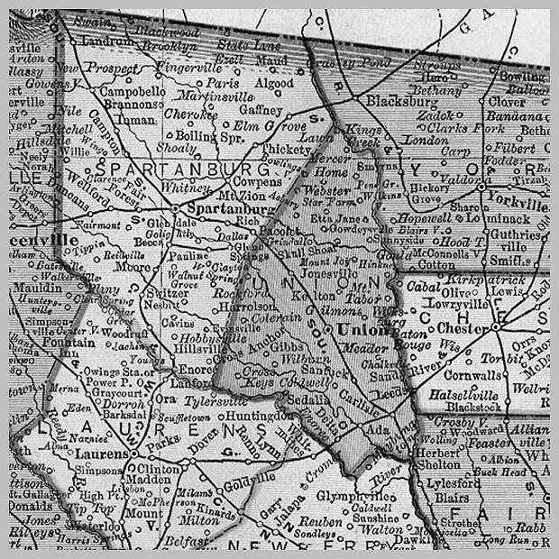
It's clear that everything East of the Broad River in what is now
Cherokee County South Carolina was then a part of York County South
Carolina. The more difficult division determination is between
Spartanburg and Union Counties in what is now Cherokee County.
The town of Gaffney was in Spartanburg County as was all of the county
west of Gaffney. So, what is now the Floyd Baker Blvd./SC11 corridor was
then in Spartanburg County. The dividing line to the East of Gaffney and
South of the Broad River is much harder to determine just glancing at a
map. The Pacolet River marks one southern boundary and the former Broad
River boundary of York/Union now marks much of the southern
Cherokee/York boundary.
Hopefully I'll be able to match a Cherokee County outline map to the map
above and show the lines a little better.
|
The following "populated places" are listed for Cherokee
County in the GNIS system:
ABINGDON : ppl : Cherokee : 345932N 0812959W : Hickory Grove
BLACKSBURG : ppl : Cherokee : 350716N 0813058W : Blacksburg South
CASHION CROSSROADS : ppl : Cherokee : 350523N 0813029W : Blacksburg South
CHEROKEE FALLS : ppl : Cherokee : 350353N 0813233W : Blacksburg South
DRAYTONVILLE : ppl : Cherokee : 350258N 0813538W : Blacksburg South
EAST GAFFNEY : ppl : Cherokee : 350448N 0813759W : Gaffney
GAFFNEY : ppl : Cherokee : 350418N 0813900W : Gaffney
GOUCHER : ppl : Cherokee : 345853N 0814150W : Pacolet Mills
GRASSY POND : ppl : Cherokee : 350813N 0814021W : Boiling Springs South
(NC)
KINGS CREEK : ppl : Cherokee : 350426N 0812613W : Kings Creek
MACEDONIA : ppl : Cherokee : 350414N 0814538W : Cowpens
SARATT : ppl : Cherokee : 345345N 0813225W : Wilkinsville
SMITH FORD : ppl : Cherokee : 345948N 0812908W : Hickory Grove
THICKETTY : ppl : Cherokee : 350059N 0814330W : Gaffney
WHITE PLAINS : ppl : Cherokee : 345937N 0814414W : Pacolet Mills
WILKINSVILLE : ppl : Cherokee : 345818N 0813159W : Wilkinsville
|
If we consider the history even further back: Note the location of the
Broad River on the above map. It is generally considered that into the
mid-1700's and earlier that the area West of the Broad River was within the
Cherokee Nation while the area East of the Broad River was within the Catawba
Nation. Further, part of this area was disputed border with North Carolina
and the early county of Tryon...
|
|
|